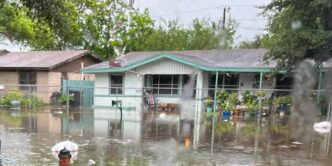

At least 16 million people are under flood watches stretching from southern Texas along the Gulf Coast to central Mississippi as severe weather continues to affect multiple regions across the United States. Authorities in Texas are searching for a driver whose vehicle was swept away Monday morning, while the National Weather Service warns of potentially life-threatening flash flooding through the week.
The dangerous weather conditions have already forced the cancellation of the FIFA Fan Fest in Houston due to heavy rains, with New Orleans facing the highest flood risk among affected cities. A moderate flood risk remains in effect for three days covering Texas, Louisiana, Mississippi and Alabama.
Main Developments Across the Southern United States
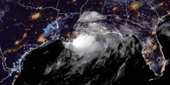
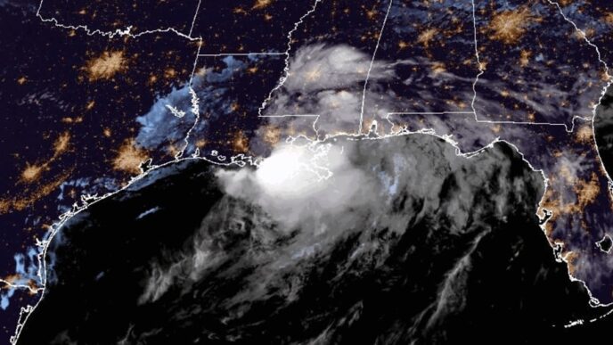
Tropical moisture from a disturbance over the Mexico-Texas border is fueling intense downpours across the Southern United States. Meteorologists expect rainfall rates between 2 to 5 inches per hour in affected areas, with total accumulations projected to reach 8 to 10 inches through Friday. Some locations could see locally higher amounts of up to 12 inches.
Flood watches are likely to expand to include Alabama later Tuesday as the weather system continues to affect the region. The National Weather Service has issued warnings about the potentially life-threatening nature of the flash flooding expected through the week.
In Bandera County, Texas, officials are conducting a search operation for a driver whose vehicle was swept away in the Texas Hill Country on Monday morning. Sheriff Joshua Teitge indicated that certain factors are giving us hope regarding the ongoing search, though the driver has not been located as of the latest reports.
What We Know So Far
The current flood situation affects a vast area of the Southern United States with multiple levels of risk and warnings in place. Here is what has been confirmed:
At least 16 million people remain under flood watches from southern Texas along the Gulf Coast to central Mississippi. A moderate flood risk is in effect for three consecutive days covering Texas, Louisiana, Mississippi and Alabama. New Orleans faces the highest flood risk among the affected metropolitan areas.
The FIFA Fan Fest scheduled in Houston was canceled due to heavy rains, affecting residents and visitors who planned to attend the event. The cancellation reflects the severity of conditions affecting the Houston metropolitan area.
Separately, 38 million people in the Midwest and Ohio Valley face severe weather on Wednesday, with the potential for a tornado outbreak. Winds greater than 75 mph are possible in affected areas from Kansas to Ohio.
Additionally, heat alerts are in effect for 13 million people in the Pacific Northwest, California and the southern Rockies, where temperatures are running 5 to 20 degrees above average.
What Happens Next
Weather conditions are expected to remain dangerous through the end of the week. A possible short-lived tropical storm could develop later Tuesday or Wednesday if the disturbance over the Mexico-Texas border moves over the Gulf of Mexico.
The severe weather risk in the Midwest and Ohio Valley extends through Thursday, when Kentucky, Tennessee and Long Island could also experience dangerous conditions. New York City is scheduled to celebrate the New York Knicks NBA Championship with a ticker-tape parade on Thursday, which could coincide with the expanded severe weather risk affecting Long Island.
Rainfall totals are expected to continue accumulating through Friday, with the potential for 8 to 10 inches across affected areas and locally higher amounts reaching up to 12 inches in some locations.
Important Details for Affected Areas
The current severe weather event affects multiple distinct regions with different types of hazards. Residents should be aware of the specific risks in their area:
Gulf Coast and Southern States: Flood watches are in effect from southern Texas to central Mississippi, with expansion likely into Alabama later Tuesday. The moderate flood risk will persist for three days. Rainfall rates of 2 to 5 inches per hour are expected, creating dangerous flash flood conditions. New Orleans residents face the highest flood risk and should monitor local emergency communications.
Midwest and Ohio Valley: On Wednesday, 38 million people face severe weather risk from Kansas to Ohio. This includes the potential for a tornado outbreak with winds exceeding 75 mph. By Thursday, the risk extends to Kentucky, Tennessee and Long Island.
Western United States: Heat alerts affect 13 million people in the Pacific Northwest, California and the southern Rockies. Temperatures are running 5 to 20 degrees above average in these regions.
The National Weather Service emphasizes that flash flooding poses a life-threatening danger. Residents in affected areas should avoid driving through flooded roadways and follow guidance from local emergency management officials.
Search Operation in Texas Continues
Bandera County authorities continue their search for the driver whose vehicle was swept away in the Texas Hill Country on Monday morning. Sheriff Joshua Teitge has not provided details about the identity of the missing driver but indicated that circumstances are giving us hope in the ongoing operation.
The incident highlights the dangers posed by rapidly rising floodwaters, particularly in areas prone to flash flooding. Drivers are urged to avoid crossing flooded roadways, as water levels can rise quickly and overwhelm vehicles.
Multiple Weather Events Affecting the Nation
The current weather pattern has created a situation where multiple severe weather events are occurring simultaneously across different regions of the United States. The Southern flooding, Midwest severe weather threat and Western heat wave represent distinct but concurrent hazards affecting tens of millions of Americans.
The combination of tropical moisture feeding into the Gulf Coast region, an active severe weather pattern in the central United States and a heat dome affecting the West has created challenging conditions across much of the country.
Residents in all affected areas should monitor local weather forecasts and emergency communications for the latest updates on conditions in their specific locations.
Frequently Asked Questions
How much rain is expected in the Southern flooding?
Rainfall totals of 8 to 10 inches are expected through Friday across affected areas, with locally higher amounts reaching up to 12 inches. Rainfall rates of 2 to 5 inches per hour are anticipated during the heaviest downpours.
Which cities face the highest flood risk?
New Orleans faces the highest flood risk among affected metropolitan areas. The flood watches cover southern Texas along the Gulf Coast to central Mississippi, with Alabama expected to be included later Tuesday.
Could a tropical storm form from this weather system?
A possible short-lived tropical storm could develop later Tuesday or Wednesday if the disturbance currently over the Mexico-Texas border moves over the Gulf of Mexico. This remains a possibility rather than a certainty.
How long will the flooding risk last?
The moderate flood risk is in effect for three days covering Texas, Louisiana, Mississippi and Alabama. Rainfall totals are expected through Friday, and the National Weather Service warns of potentially life-threatening flash flooding through the week.
What areas face severe weather in the Midwest?
On Wednesday, 38 million people face severe weather from Kansas to Ohio, with the potential for a tornado outbreak and winds greater than 75 mph. By Thursday, the risk extends to Kentucky, Tennessee and Long Island.
Authorities continue to monitor conditions across all affected regions as the severe weather pattern persists. Residents should remain alert to changing conditions and follow all guidance from local emergency management officials and the National Weather Service.