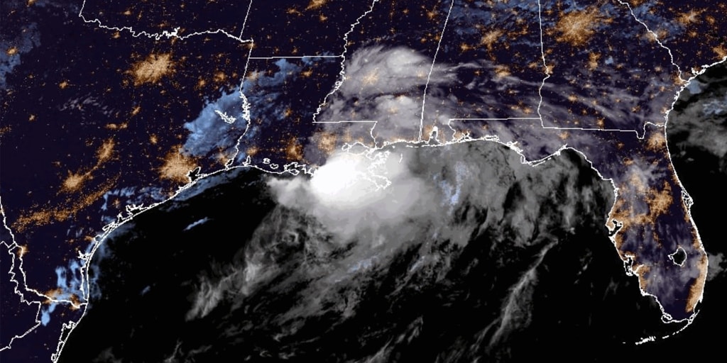
Tropical Storm Arthur, the first tropical storm of the Atlantic basin season, was downgraded to a low pressure area along the upper Texas coast Wednesday night. Despite the weakening, the National Hurricane Center warns that Arthur’s remnants will bring life-threatening flooding and heavy rains to the southeastern United States through Friday, with a rare high-risk flood level in effect for multiple states.
All coastal watches and warnings were discontinued Wednesday night as the storm’s maximum sustained winds dropped to 35 mph. However, officials emphasize that the most dangerous phase of this weather event may still lie ahead as the system moves across the region.
Main developments
The National Hurricane Center has issued a rare high-risk flood level for Louisiana, southern Mississippi, southern Alabama, and the western Florida Panhandle. This designation indicates the potential for dangerous and life-threatening flash flooding conditions across these areas.
New Orleans and Atlanta are currently in a moderate risk zone for flooding as the storm’s remnants continue their path across the southeastern states. The storm is expected to cross the southeast from Thursday through Friday, bringing sustained heavy rainfall to communities already saturated from earlier precipitation.
Michael Brennan, director of the National Hurricane Center, addressed the ongoing threat in a statement. “The main threat from Arthur is going to be a prolonged, multiday, heavy rainfall event that could produce dangerous to life-threatening flash flooding,” Brennan said.
Weather forecasters expect rainfall totals between 5 and 10 inches across affected regions, with isolated areas potentially receiving up to 20 inches. Rainfall rates could reach 3 inches per hour at times, creating rapid accumulation that overwhelms drainage systems and waterways.
What we know so far
The weather system has already produced significant impacts across multiple states. Over 200 storms were recorded Wednesday, with tornadoes reported across Wisconsin, Illinois, and Alabama. The severe weather outbreak has placed approximately 63 million people at risk for tornadoes from the Tennessee River Valley to New England, with that risk continuing through Thursday.
Tragically, a 15-year-old drowned near Houston on Tuesday in a retention pond, marking a confirmed fatality associated with the storm conditions. The incident highlights the dangers posed by flooding, even in areas that may seem manageable.
Picayune, Mississippi, located approximately 50 miles from New Orleans, declared a state of emergency on Tuesday after receiving 7 inches of rain in just 6 hours. The rapid accumulation overwhelmed local infrastructure and prompted emergency response measures.
In Effingham County, Illinois, business owner Michael Yager described his reaction to the storm damage. “I didn’t have a reaction, I guess. I was kind of speechless, and for lack of words,” Yager said.
Residents across the affected region have been taking precautions. Luke Barwick, a resident who filled sandbags in Covington, Louisiana, explained his decision. “We both decided we got so much rain yesterday at our house that it was probably a good idea just to pick up a few bags,” Barwick said.
What happens next
The storm system is expected to continue moving across the southeastern United States through Friday, bringing continued flooding risks to the affected areas. Residents in Louisiana, southern Mississippi, southern Alabama, and the western Florida Panhandle should remain alert for flash flooding conditions.
The tornado risk for the approximately 63 million people from the Tennessee River Valley to New England is expected to continue through Thursday. Residents in these areas should monitor local weather alerts and have plans in place to seek shelter if warnings are issued.
New Orleans Mayor Helena Moreno has been monitoring the situation as the city faces moderate flood risk. Local officials across the affected regions are coordinating emergency response efforts and urging residents to take precautions.
Important details
The following areas face the highest flood risk:
High-risk flood areas include Louisiana, southern Mississippi, southern Alabama, and the western Florida Panhandle. Moderate-risk areas include New Orleans and Atlanta.
Expected rainfall totals range from 5 to 10 inches generally, with isolated totals up to 20 inches possible in some locations. Rainfall rates may reach 3 inches per hour at peak intensity.
The timeline for the most significant impacts extends from Thursday through Friday as the storm crosses the southeast region.
Despite the severe weather conditions, a World Cup match played indoors in Houston was not disrupted by the storm.
Residents in affected areas should avoid walking or driving through flooded areas, as rapidly moving water poses significant dangers. Those near retention ponds, creeks, and low-lying areas should exercise extreme caution, particularly given the tragic drowning that occurred Tuesday near Houston.
Frequently asked questions
Is Tropical Storm Arthur still active?
Tropical Storm Arthur was downgraded to a low pressure area along the upper Texas coast Wednesday night. All coastal watches and warnings have been discontinued, though flooding and severe weather risks continue across the southeastern United States.
Which areas face the highest flooding risk from Arthur?
A rare high-risk flood level is in effect for Louisiana, southern Mississippi, southern Alabama, and the western Florida Panhandle. New Orleans and Atlanta are in moderate risk zones. Rainfall totals of 5 to 10 inches are expected, with isolated areas potentially receiving up to 20 inches.
How long will the flooding threat continue?
The National Hurricane Center warns that life-threatening flooding and heavy rains will continue through Friday as the storm’s remnants cross the southeastern United States. The tornado risk for 63 million people is expected to continue through Thursday.
Was Arthur the first tropical storm of the season?
Yes, Arthur is the first tropical storm of the Atlantic basin season. Despite being downgraded to a low pressure area, the system continues to pose significant flooding and severe weather risks across multiple states.
Officials continue to monitor conditions across the affected region as residents prepare for continued rainfall and potential flooding. The National Hurricane Center and local emergency management agencies urge those in high-risk areas to stay informed through official weather channels and follow guidance from local authorities regarding flooding precautions and potential evacuations.